
Traveling to Paducah
Visit goky.ky.gov for the latest traffic alerts, construction activity and weather conditions from the Kentucky Transportation Cabinet.
Geographically Centered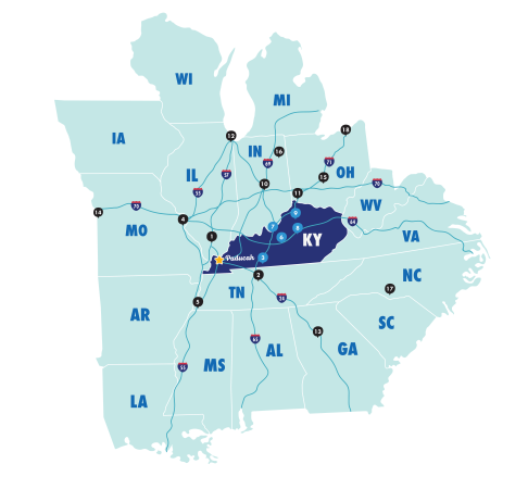
At the meeting point of the Ohio and Tennessee Rivers, Paducah is easy to reach and unforgettable to experience. Located halfway between Nashville and St. Louis along Interstate 24, our central spot makes getting here simple for attendees traveling by car.
To spark a little adventure, our Road Trip Paducah, Kentucky inspiration guide highlights five regional routes—perfect for discovering the many ways to explore Kentucky and its surrounding destinations before or after your event.
*Exit 16 will be temporarily closed for construction during summer 2026. Visitors are encouraged to take Exit 11 to access that part of town. More information can be found at WPSD Local 6.
Nearby Cities
Paducah is within an afternoon's drive of many major metropolitan areas including:
-
140 miles northwest of Nashville, Tennessee
-
170 miles miles southeast of St. Louis, Missouri
-
180 miles north of Memphis, Tennessee
-
220 miles west of Louisville, Kentucky
-
300 miles southwest of Indianapolis, Indiana
-
320 miles west of Cincinnati, Ohio
-
370 miles south of Chicago, Illinois
-
380 miles northwest of Atlanta, Georgia
Fly Barkley!
Flying to Paducah is easy and convenient at Barkley Regional Airport (PAH), which has proudly served the region since 1946. A modern terminal welcomes travelers to a relaxed airport experience with short lines and small crowds. Plus, plenty of parking is available just steps from the terminal.
Barkley offers daily nonstop service to major airline hubs, providing easy one-stop connections to hundreds of destinations across the U.S. and beyond via United Airlines, operated by SkyWest Airlines.
For added convenience, Paducah Area Transit System (PATS) Dial-A-Ride offers scheduled transportation between the airport and area hotels with advance registration, making arrivals and departures smooth from curb to check-in.

Central access means less time traveling, more time connecting. Whether by road or air, Paducah’s convenient location makes it easier for attendees to say yes to your event and to enjoy every moment once they arrive.

Begin your trip with a flight into Barkley Regional Airport, conveniently located 5 miles west of Paducah.


